
Yosemite in a Day: Summer Edition
Prepare for an unforgettable adventure in Yosemite National Park during the summer months (June through August). To make the most of your day and avoid the crowds, set off bright and early. As you journey through, don't miss the opportunity to soak in the awe-inspiring vistas. Keep your senses alert for wildlife crossing the roadway, adding an element of excitement to your drive. Below, we've crafted a suggested itinerary starting from the Visitors Center. Feel free to tailor it to your schedule, and if you find yourself running behind, don't worry! Flip the order of stops for a seamless experience. Let the exploration begin!
Yosemite in 2026: No Vehicle Reservations Required
Visiting in 2026? Great news! Yosemite National Park will not require day-use or vehicle reservations, even during peak travel dates.
The entrance fee remains $35 per vehicle for seven days, and purchasing your digital pass in advance is strongly encouraged to reduce wait times. For the best parking availability, plan to arrive early in the morning (at the entrance by 7 A.M.). For real-time parking and park updates, text YNPTRAFFIC to 333111. You can also get Emergency(ish) Alerts by texting YOSEMITE to 333111.
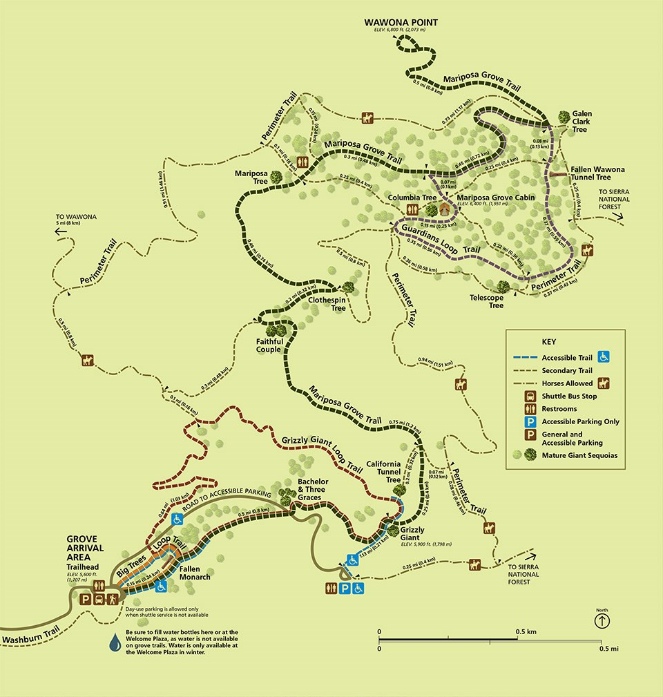
The Mariposa Grove of Giant Sequoias


The Mariposa Grove of Giant Sequoias is at the South Gate Entrance of Yosemite National Park
The Mariposa Grove has over 500 mature giant sequoia trees and a variety of trails, from easy to strenuous and accessible. Some of the giant sequoias of Mariposa Grove are approximately 2,000 years old. This impressive natural wonder was pivotal to the creation of Yosemite National Park and has been revered by the First Native People, followed by adventurers such as Galen Clark, John Muir, and Teddy Roosevelt.
How to Access The Grove
Park at Welcome Plaza and take the free shuttle to the Mariposa Grove Arrival Area. Note: The shuttle bus from the Welcome Plaza parking to the Mariposa Grove Arrival Area is weather-dependent. A late spring or early fall snow can temporarily close the road access. Visitors can snowshoe, cross-country ski, or hike into the Grove via the two-mile Washburn Trail when the road is closed.
Prepare for your Adventure
Wear a hat and good hiking shoes, and carry plenty of water. Drinking fountains and water refilling stations are at the Welcome Plaza and the Arrival Area.
Recommended Hikes
- Big Trees Loop Trail: 0.3-mile - EASY (1-2 hours). You will see many Giant Sequoias, including the Fallen Monarch, and interpretive panels on the life and ecology of Giant Sequoias.
- Grizzly Giant Loop Trail:2-miles - MODERATE (2-3 hours) Discover many more Giant Sequoia trees, including the Bachelor and Three Graces, the Grizzly Giant, and the California Tunnel Tree.
- Mariposa Grove Trail: 7-miles - STRENUOUS (4-6 hours) Other notable trees included are the Faithful Couple and Clothespin Tree. You can also visit Wawona Point and the Mariposa Grove Cabin along this route.
Accessibility
For those with a handicap placard, you can access parking at the Arrival Area and near the Grizzly Giant Tree. Restrooms are also available in these parking areas.
The beauty of Mariposa Grove is only the beginning of your Yosemite explorations. Buckle up. The next stop is not far away!
Explore the Historical Heart of Yosemite: A Guide to Wawona


The historic Wawona Hotel inspires the imagination with visions of yesteryear.
Explore the rich history and activities at one of the park's historic hubs:
- Discover the charm of the Wawona Hotel, a distinguished National Historic Landmark and one of California's original mountain resort hotels. The Wawona Hotel is closed for a comprehensive condition assessment by the National Park Service. There is currently no reopening date for the hotel.
- Immerse yourself in the past at the Yosemite History Center, home to a fascinating array of historic buildings. Delve into the past as you explore the exteriors of these buildings and engage with informative interpretive signage that tells the story of the park's heritage. During the summer, visitors can also enjoy exhibits inside the Chinese Laundry Building and the Acting Superintendent's Office, take a leisurely ride on horse-drawn wagon, or witness the craftsmanship of blacksmiths as they forge iron tools.
- Enjoy a stroll along the Meadow Loop Trail, a dog-friendly trail spanning 3.5 miles of flat terrain.
- Experience the natural beauty of Chilnualna Falls with a moderately easy hike to the first cascade (2-mile round trip). For a more challenging adventure, trek to the upper cascades (8 miles round trip, 2,300 ft elevation gain), mindful of possible snow on the trail in early spring.
- Tee off at Wawona Golf Course, offering traditional ball and disc golf options. Reservations are required.
- Indulge in a delightful dining experience at Wawona Hotel, often accompanied by live musical performances by Tom Bopp, a talented musician and Yosemite historian.
For your next adventure:
- Embark on a scenic drive along Glacier Point Road, stretching 16 miles to the breathtaking Glacier Point.
Glacier Point

Glacier Point at Sunrise
Embark on an adventure along Glacier Point Road, where breathtaking vistas and exhilarating hikes await:
- McGurk Meadow Hike: Immerse yourself in the beauty of late summer wildflowers on this easy 2-mile round-trip stroll. Keep an eye out for stunning blooms near the creek crossing.
- Dewey Point Hike: Moderate in difficulty, this 8-mile round trip offers mesmerizing panoramic views.
- Sentinel Dome Hike: Trek 2.2 miles round trip to experience the best 360-degree vistas of the valley and high country. Don't miss the chance for a stunning photo opportunity!
- Extend your adventure by continuing the Sentinel Dome Hike on a 5-mile loop to include Taft Point and the Fissures.
- Washburn Point and Glacier Point: Marvel at the majestic Nevada and Vernal Falls from these vantage points, offering unparalleled views of Yosemite Valley from 3,200 feet above. Capture breathtaking photos of Mt. Hoffman, Cathedral Peak, Mt. Starr King, Mt. Clark, and other iconic landmarks of the Yosemite high country.
- Glacier Point is renowned for its captivating sunsets, full moons, and starry skies, providing an ideal setting for memorable photographs. Check out the "10 Best Stargazing Spots in Yosemite and Madera County" for more incredible stargazing locations within the park.
Please note: During busy periods Yosemite National Park may offer a free shuttle service is available from Badger Pass to Glacier Point, with limited vehicle access.
For your next adventure, head back along Glacier Point Road from Glacier Point, then turn right onto Wawona Road at Chinquapin. Drive 7.7 miles towards Yosemite Valley, passing through the picturesque Wawona Tunnel before reaching your next destination, Tunnel View.
Tunnel View

Tunnel View is one of the most photographed vistas in the world. Photo by Darvin Atkeson.
As you emerge from the tunnel, take a moment to marvel at the awe-inspiring panorama of Bridalveil Fall, Half Dome, Clouds Rest, and El Capitan. This breathtaking vista offers a fantastic photo opportunity to capture the essence of Yosemite's majestic beauty.
- Parking in Paradise: Safely park your vehicle on either side of the tunnel and soak in the grandeur of the surrounding landscape. With such iconic landmarks in sight, this spot promises an unforgettable moment.
- Quintessential Yosemite: Don't let this quintessential Yosemite experience pass you by! Whether you're an amateur photographer or a seasoned pro, Tunnel View offers the perfect backdrop for capturing stunning images of nature's splendor.
Bridalveil Fall and More


Discover the beauty and history of Yosemite Valley with these iconic landmarks and breathtaking views awaiting your exploration.
El Capitan and Bridalveil Fall: Drive approximately two miles from Tunnel View to reach the valley floor. Here, you can park and admire the awe-inspiring sights of El Capitan and Bridalveil Fall, also known as Pohono by the native Ahwahneechee people. Bridalveil Fall, the first grand waterfall many visitors encounter in Yosemite, adds to the enchantment of the landscape.
Swinging Bridge Picnic Area: Continue your journey three miles further into the valley to discover this iconic family picnic spot, offering a perfect setting for a relaxing outdoor meal amidst Yosemite's natural beauty.
Yosemite Chapel: Venture just over half a mile along Southside Drive to uncover the historic Yosemite Chapel, constructed in 1879. Enjoy stunning views of Yosemite Falls from outside the chapel, the oldest continuously used building in Yosemite Valley. Nearby, Cooks Meadow, across the street from the chapel, offers opportunities to spot wildlife such as peregrine falcons, coyotes, mule deer, and black bears. Take a moment to appreciate the serene surroundings and immerse yourself in nature's wonders.
Sentinel Bridge: Follow the road east from Yosemite Chapel to Sentinel Bridge. Positioned at the bridge's center, capture breathtaking photos of Half Dome towering over the tranquil Merced River, often reflecting the majestic scenery.
Follow the signs guiding you to the main day-use parking area, Curry Village, or Yosemite Lodge parking. Once parked, leave your car behind to visit east Yosemite Valley. Hop aboard the free Yosemite Valley shuttle or explore on foot— the choice is yours!
The FREE Yosemite Valley Shuttle

Discover the beauty of Yosemite Valley with ease by utilizing the Yosemite Valley Shuttle, your free ride to explore the heart of Yosemite Valley. The shuttle runs every 10 to 20 minutes from 7 am to 10 pm, with convenient stops at key destinations. Remember that shuttle service varies by season, so staying informed is essential.
Prioritize planning with our "Know Before You Go" approach by checking the current routes and stops in service.
Begin your journey at Shuttle Stop 1, Yosemite Village, and Day Use Parking. Another parking option can be found at Shuttle Stop 7, Yosemite Valley Lodge/Yosemite Falls.


Opting for the convenient shuttle service allows you to effortlessly hop between major attractions while setting out on foot, unveils hidden gems, and allows for a deeper connection with the park's stunning landscapes. Whichever mode of transportation you choose, prepare for an unforgettable journey through one of nature's most magnificent playgrounds.
Shuttle Stop 1: Day Parking—Leave your car parked for the day and enjoy a hassle-free exploration of Yosemite Valley with the free shuttle service, which covers all major attractions.
Shuttle Stop 2: Yosemite Valley Welcome Center (located next to Village Store) – Ranger-staffed information desk and bookstore, informational and directional exhibits. At the nearby Village Store, discover groceries, gifts, camping essentials, and souvenirs.
Shuttle Stop 3: The Ahwahnee – Ideal for a delightful lunch experience. Reservations and a dress code are required for dinner. Enjoy a leisurely meal with stunning views from the 34-foot-high windows. For more information, call (209) 372-1489
Shuttle Stop 4: Degnan's Kitchen – Savor deli sandwiches, signature salads, artisan pizzas, coffee, and more at Degnan's Kitchen.
Shuttle Stop 5: Yosemite Exploration Center & Museum – Explore the Yosemite Conservancy Bookstore and Yosemite theatre, which showcases the "Spirit of Yosemite" film. Then, dive into the cultural history of Yosemite's native peoples at the Yosemite Museum and Indian Cultural Village.
Shuttle Stop 6: Lower Yosemite Falls—Embark on a scenic half-mile walk to the base of Lower Yosemite Falls, which offers picturesque views.
Shuttle Stop 7: Yosemite Valley Lodge – Rent bikes in-season and swim at their incredible Olympic-sized swimming pool. Dine at Base Camp eatery, The Mountain Room, or The Mountain Room Lounge. Guided tours around Yosemite Valley and Glacier Point depart from here. For info and reservations, call (209) 372-4386.
Shuttle Stop 14: Curry Village (eastbound) – Enjoy bike and raft rentals in summer and dine at Pizza Deck and Meadow Grill. Visit the Mountaineering School located here.
Shuttle Stop 16: Happy Isles – Explore the Happy Isles Nature Center and embark on the Mist Trail hike to the Vernal Falls Footbridge, offering fantastic photo opportunities. Continue your hike to Vernal Falls and Nevada Falls for more stunning views.
Shuttle Stop 17: Mirror Lake – Experience Yosemite Valley's seasonal "lake" with easy and moderate hike options, including a 2-mile round trip to the lake and back or a 5-mile loop around the lake.
Shuttle Stop 19: Curry Village (westbound) – Discover dining, shopping, and lodging options at Curry Village.
These are just a few of the adventures awaiting you in Yosemite Valley. As you depart via Northside Drive, another adventure begins.
Valley View and More

Sit along the Merced River and enjoy the Valley View
After a fulfilling day exploring Yosemite Valley's wonders, there are still a few gems to discover before you conclude your journey:
- El Capitan Meadow: Marvel at the awe-inspiring views of the towering El Capitan to the north and the majestic Cathedral Rocks formations to the south, offering a glimpse of Yosemite's iconic granite monolith.
- Bridalveil Fall Turnout: Stop at this small turnout on the left side of Northside Drive to admire breathtaking views of Bridalveil Fall, framed by the Merced River and perhaps adorned with blooming Dogwood trees.
- Valley View (Gates of the Valley): Similar to Tunnel View, this spot provides a panoramic vista of Yosemite Valley with the Merced River flowing in the foreground and towering granite walls above. Look for the pullout on the left just past the Bridalveil Fall turnout before Pohono Bridge.
- Fern Spring and Bridalveil Meadow: Two brief stops along the way back to Wawona Road, where you can witness the charming "smallest waterfall in Yosemite" at Fern Spring and explore the historic site of President Teddy Roosevelt's 1903 visit with John Muir at Bridalveil Meadow.
Before bidding farewell to Yosemite, consider these parting gifts:
- If time permits and the road is open, venture into the Yosemite high country via Tioga Road for a closer look at the breathtaking landscapes of the eastern Sierra Nevada.
- Alternatively, don't overlook the stunning beauty of Hetch Hetchy, an often underestimated yet equally remarkable area of Yosemite National Park.
These final adventures promise unforgettable experiences and lasting memories as you conclude your Yosemite Valley journey.


______________________________________________________________________________________
Like what you see? Save any (or all) of these pins to your travel planning board(s) to give you an easy way to find your way back here! Also check out our other itineraries and blog posts for more ideas and pins!